
In Rome, the city centre is a “30 zone” from today too. And they published a map!

It’s just so much more sensible than 50 km/h.
Less deadly for pedestrians too.
Wales implemented a pretty widespread version of this, changing roughly a third of all of their roads from 30 mph to 20 mph (pretty close to 50 and 30 kph respectively). Test areas before the full implementation seemed to go well, and the first year of the reduced limit saw casualties on affected roads drop by a quarter compared to the prior year. That’s only one year of data, and casualties were already trending down anyway, but it does seem promising
It has been very controversial, though. A lot of people do not like it and are fighting to repeal it
On the website of the municipality there is a list of all streets that will have their maximum speed lowered:
https://www.utrecht.nl/wonen-en-leven/verkeer/verkeersveiligheid/wat-doet-de-gemeente/straten-30-kilometer-per-uur-makenSadly they don’t show a map. That would be a nice visualization.
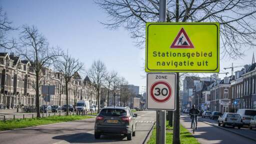
What does the sign “Stationsgebied navigatie uit” mean? Is there some municipal navigation system that is turned off during construction?
It means they recommend turning off navigation. The goal is to encourage drivers to pay attention to the road, read signage, and keep an eye out for construction.
It’s also often used because the navigation might be wrong due to changes and restrictions put in place for the road works.
If the navigation gives the wrong instructions, that might lead to distraction and in turn dangerous situations. Especially so in a construction zone.Personally I don’t turn off the navigation when I see it, but I take it as a reminder that the navigation will probably be incorrect on the next stretch.